IN Brief:
- SatVu has started commercial operations for HotSat-2.
- The satellite delivers high-resolution thermal intelligence for critical infrastructure, defence, economic monitoring, and climate applications.
- Space-based thermal sensing is becoming an operational data layer for industrial activity, not only an environmental monitoring tool.
SatVu has started commercial operations for HotSat-2, moving its high-resolution thermal satellite service into customer tasking and data delivery.
The UK company is using HotSat-2 to provide commercial thermal intelligence products for defence, intelligence, economic monitoring, energy infrastructure, and climate resilience applications. The service is designed to reveal the operating state of critical assets by showing whether infrastructure is active, inactive, heating, cooling, or changing over time.
HotSat-2 follows the earlier HotSat-1 pathfinder mission, which demonstrated the commercial value of high-resolution thermal imaging before a camera anomaly ended operations after roughly six months in orbit. The second satellite has now moved into routine commercial delivery, with customers able to task imagery, access operational data, and integrate thermal intelligence into workflows through SatVu’s platform, APIs, and enterprise services.
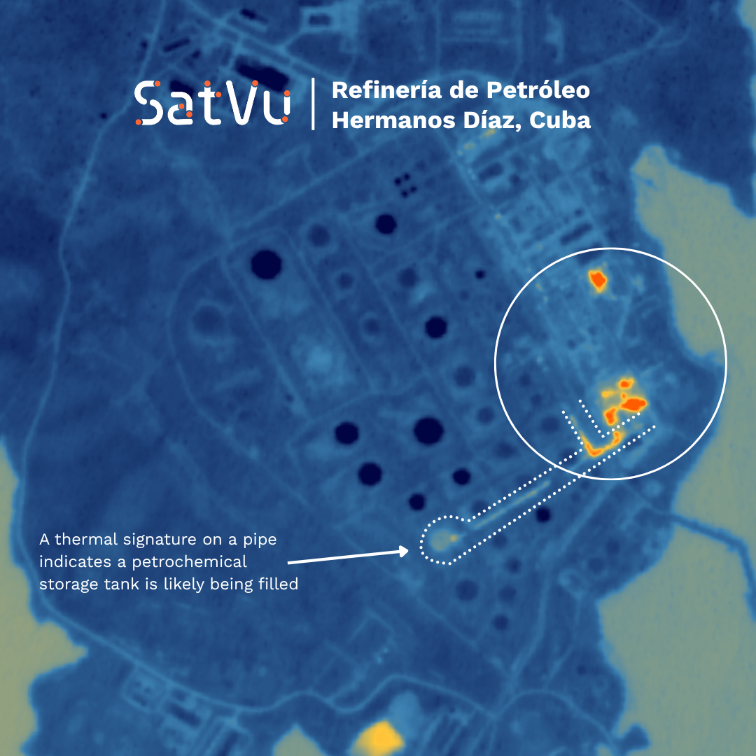
Recent HotSat-2 imagery has been used to examine activity at strategic infrastructure sites, including energy facilities in Cuba, South Africa, and Saudi Arabia. Earlier first-light imagery monitored the Hermanos Díaz refinery in Cuba, the Jamnagar refinery in India, and the Gorgon LNG project in Australia. Thermal data can indicate activity patterns that are not visible in conventional optical imagery.
Thermal Earth observation adds a separate measurement layer to optical imaging and synthetic aperture radar. Optical systems show visible structure, while SAR can operate through cloud and darkness to reveal surface and geometry changes. Thermal sensing shows heat signatures that can indicate whether equipment is running, cooling, under load, or changing usage patterns.
The payload and processing chain are central to the service. A commercial thermal satellite depends on detector performance, calibration, onboard stability, downlink, tasking, processing, analytics, and delivery into customer systems. The value lies in repeatable data products rather than isolated demonstration images.
Defence and security markets are increasing their reliance on persistent sensing and rapid interpretation. Work on UK ground-based air-defence radar testing and Project CRENIC’s electronic-warfare jammer prototype testing sits in a different part of the sensing and assurance chain, but the same pattern is visible: sensors, validation, and data fusion are becoming core operational infrastructure.
SatVu’s applications extend beyond defence. Energy traders, infrastructure operators, insurers, climate analysts, and government agencies can use thermal signatures to assess industrial activity. A refinery, data centre, LNG plant, port, airfield, or power facility may appear static in optical imagery while its thermal profile reveals load, downtime, restart, or changing operational intensity.
Independent thermal data is valuable where direct access is limited, delayed, or unavailable. Sanctions, conflict, remote sites, commercial confidentiality, and restricted ground reporting all create gaps in conventional monitoring. Space-based thermal sensing offers a repeatable measurement layer that can be applied across regions and time zones.
SatVu’s next operational challenge is scale. A single satellite can demonstrate value and support selected tasking, but customers monitoring fast-moving industrial or security events need revisit frequency, low latency, dependable calibration, and consistent delivery. The company’s constellation plan, including additional HotSat satellites, will determine whether high-resolution thermal imagery becomes a routine operational feed rather than a specialist analytical product.
HotSat-2’s commercial start gives the UK thermal imaging sector a live test of that model. Imaging payloads are now judged not only by resolution and sensitivity, but by the quality of decisions that their data can support.